Is Mount Shasta an Active Volcano? The Science Behind California's Sleepy Giant
- September 20, 2026
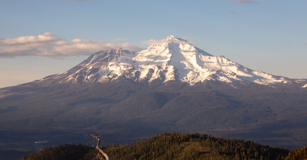
Photo by Mazin Omron via Pexels
Yes, Mount Shasta is an active volcano. The United States Geological Survey classifies Mount Shasta as active, with its most recent eruption occurring approximately 230 years ago, around 1786 according to tree-ring dating. This is not a dormant giant awaiting indefinite slumber nor an extinct remnant of volcanic fury long past. Mount Shasta continues to breathe, simmer, and shift beneath its blanket of snow and ice. For the communities nestled at its feet and along the highways that thread through its shadow, this classification is not abstract geology but an immediate practical concern.
The Science of "Active": What Volcanologists Actually Mean
The word "active" carries specific meaning in volcanology that differs from casual usage. A volcano is classified as active when it has erupted within the past 10,000 years, which corresponds to the Holocene epoch. By this measure, Mount Shasta qualifies.
The distinction between active, dormant, and extinct often confuses observers, yet the boundaries are surprisingly precise. A dormant volcano has not erupted within the past 10,000 years but retains the potential for future activity. These peaks have fallen silent but not permanently. An extinct volcano has ceased all volcanic activity entirely, its magma source having cooled or moved beyond reach. Mount Shasta shows no signs of belonging to either category. This distinction matters for monitoring priorities and emergency planning, which is why USGS scientists invest significant resources in tracking this particular peak.
The volcano's activity level also earns it a prominent place in the National Volcano Early Warning System, which assigns threat scores based on multiple factors including eruption history, volcanic unrest indicators, and proximity to population centers. Mount Shasta ranks among the highest-threat volcanoes in the United States, a classification that reflects both its geological vitality and its exposure to human consequence.
The Last Eruption and What the Evidence Tells Us
Mount Shasta's most recent eruptive episode occurred in the late 18th century, with the primary event dating to approximately 1786. Tree-ring analysis provides this date through examination of trees that show growth anomalies consistent with volcanic activity. The eruption was relatively modest compared to some of Mount Shasta's ancient outbursts, producing pyroclastic flows and lahars that descended the mountain's flanks but likely did not dramatically alter the regional landscape.
What makes this timing significant is its recency relative to human civilization. The 1786 eruption occurred during the period when European and American exploration of the region was just beginning. Indigenous peoples of the region, including the Shasta, Modoc, and other tribes, certainly witnessed and passed down accounts of volcanic activity. The oral traditions of these communities may hold additional records of eruptions, though scientific dating methods provide the most precise timelines available.
Since that eruption, Mount Shasta has remained quiet in terms of visible activity, but quiet should not be mistaken for dead. Geological evidence reveals that Mount Shasta has experienced numerous eruptions over the past 10,000 years, with recurrence intervals ranging from approximately 200 to 600 years between significant events. Given that the last eruption occurred roughly 230 years ago, the volcano is operating well within its historical pattern of activity.
Current Unrest: Seismicity and Deformation Monitoring
The USGS California Volcano Observatory operates a sophisticated monitoring network throughout the Cascade Range, and Mount Shasta receives continuous attention from this system. Seismic monitoring forms the backbone of this observation capability, with instruments positioned throughout the region to detect and locate earthquakes that might indicate magma movement or hydrothermal activity.
Current data shows no significant earthquake swarms beneath Mount Shasta that would suggest imminent volcanic activity. The volcano sits within a seismically active region, and small earthquakes occur throughout the area, but the patterns that would indicate rising magma or increasing volcanic pressure are not present in recent records. This absence of unrest represents normal background activity for an active volcano.
Geodetic monitoring, which tracks ground deformation using GPS stations and satellite interferometry, similarly shows no evidence of the inflation or swelling that often precedes eruptions. When magma accumulates beneath a volcano, it typically causes the ground surface to uplift or shift in measurable ways. Mount Shasta's ground surface remains stable according to these measurements, providing additional assurance that no eruption is imminent.
This monitoring does not, however, indicate safety. Active volcanoes can remain quiet for centuries before awakening. The absence of current unrest simply means that the probability of imminent eruption remains low, not that the volcano has lost its active status.
What Lies Beneath: The Fumaroles and Hydrothermal System
Even without eruptions, Mount Shasta exhibits signs of residual volcanic heat. Fumarole activity persists at the summit, where vents release gases including steam, carbon dioxide, and sulfur dioxide into the atmosphere. These vents represent pathways through which volcanic gases escape from the magma chamber below, indicating that heat continues to move through the system even without eruptive episodes.
The hydrothermal system beneath Mount Shasta represents another indicator of ongoing volcanic activity. Hot springs and geothermal features throughout the region owe their existence to heat radiating from below. While some of these features occur at significant distances from the volcano, they reflect the same thermal regime that powers eruptions. This system essentially represents Mount Shasta breathing, though at a pace far slower than what would accompany an active eruption.
Scientists studying Mount Shasta's hydrothermal system have identified circulation patterns where cold surface water infiltrates the ground, descends toward heat sources, and returns to the surface as heated water or steam. This process requires an active heat source, which confirms that Mount Shasta's internal engine continues to operate. Changes in hydrothermal output could provide early warning of changing conditions.
The Eruption Scenario: What Scientists Believe Would Occur
Understanding what an eruption at Mount Shasta might look like requires examining the volcano's eruptive history and the behavior of similar stratovolcanoes. Scientists studying Mount Shasta's past eruptions have identified characteristic patterns that would likely repeat in future activity.
The most probable eruption scenario involves dome growth, where viscous lava accumulates at the summit and expands outward rather than flowing freely. This type of eruption produces significant hazards including pyroclastic flows, which are superheated clouds of gas, ash, and rock that race downslope at temperatures exceeding 1,000 degrees Fahrenheit and speeds of up to 450 miles per hour. Such flows would threaten everything in their path, incinerating forests and burying terrain beneath hot volcanic material.
Lahars represent another major hazard associated with Mount Shasta eruptions. These volcanic mudflows form when water mobilizes loose volcanic debris, creating fast-moving slurries capable of traveling tens of miles from the volcano. Mount Shasta's heavy snowpack makes lahars particularly likely during any eruption that produces significant heat, as melting ice and snow would mix with volcanic material to create devastating flows. The town of Mount Shasta itself, sitting approximately 15 miles from the summit, falls within potential lahar pathways, as do areas along the McCloud River and other waterways draining the volcano.
The communities most at risk include Mount Shasta, Weed, McCloud, Dunsmuir, and numerous smaller settlements scattered throughout Siskiyou County. The total population within 30 miles of the volcano exceeds 200,000 people during peak visitor seasons, though permanent residents number somewhat fewer. Interstate 5, the West Coast's major north-south transportation corridor, passes within the potential impact zone, meaning an eruption would have transportation and economic implications far beyond the immediate vicinity.
The Monitoring Network and What It Detects
The USGS California Volcano Observatory maintains an integrated monitoring system specifically designed to provide early warning of volcanic unrest at Mount Shasta and other Cascade peaks. This network combines seismic monitoring, ground deformation measurements, gas sampling, and thermal imaging to create a comprehensive picture of volcanic conditions.
Seismic stations throughout the region record ground vibrations that allow scientists to locate earthquakes and characterize their source. Volcanic earthquakes typically show distinctive signatures that differ from tectonic earthquakes, allowing monitoring personnel to identify patterns that might indicate magma movement. When earthquake activity beneath Mount Shasta increases beyond background levels, scientists can assess whether the activity represents volcanic unrest warranting increased monitoring or public communication.
GPS receivers installed around the volcano track minute movements of the ground surface with precision measured in millimeters. These measurements detect the swelling or deformation that typically accompanies magma accumulation. Satellite-based radar interferometry supplements ground-based GPS, providing additional coverage and the ability to detect subtle changes across the entire edifice.
The system also includes gas monitoring equipment that measures emissions from fumaroles and measures atmospheric concentrations of volcanic gases. Sulfur dioxide and carbon dioxide emissions can indicate changes in volcanic activity, as increased gas release often precedes eruptions. Thermal imaging can detect increases in surface temperature that might indicate rising heat from below.
Understanding the Real Risk
Mount Shasta's status as an active volcano should prompt awareness rather than alarm. The probability of eruption in any given year remains low, likely less than one percent based on historical recurrence intervals. The volcano has not shown signs of imminent awakening in current monitoring data.
What the active classification does provide is context for preparedness. Communities in the shadow of Mount Shasta have developed emergency plans that account for volcanic hazards. Residents and visitors should understand evacuation routes and shelter locations. The presence of an active volcano also influences land use decisions, building codes, and infrastructure planning throughout the region.
For those who live near Mount Shasta or visit the area, the volcano's activity represents an opportunity rather than merely a threat. Active volcanoes create the rich soils, stunning landscapes, and geothermal features that make the region beautiful and productive. Understanding the science behind Mount Shasta's classification allows appreciation of this volcanic heritage while maintaining appropriate respect for the power that continues to shape the mountain.
The USGS monitoring network operates continuously, and any significant change in conditions would trigger immediate alerts through the Volcano Notification Service. Staying informed through this service and local emergency management agencies represents the most practical action available to those who wish to understand and prepare for volcanic risk. Mount Shasta sleeps, but it has not stopped watching.